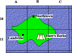
Maps

Maps often use a grid or system of coordinates to fix the position of a place on a map.
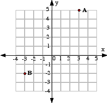
Y8_Coordinates_01.gif

On this map the approximate locations of the three places can be given as:

Northtown B10

Landville A11

Hare's Rocks B11

Mathematical Co-ordinates

In mathematics, the position of points can be given much more accurately.

Two number lines are drawn at right angles. This grid is called a number plane or a Cartesian graph.

Y8_Coordinates_02.gif

The horizontal axis is called the x-axis.

The vertical axis is called the y-axis.

The x-axis and the y-axis cross at the origin, O

A point is given by a pair of coordinates (x, y).

Coordinates are sometimes called ordered pairs.

The first number is the position along the x-axis.
The second number is the position along the y-axis.

e.g. Point A is given by (3, 5)

Point B is given by (-3, -2)

Latitude and Longitude

The Earth is very nearly a perfect sphere Y8_Coordinates_03.gif.

On a globe of the Earth there are two sets of lines that form a special grid which can be used to locate any point on the surface of the Earth using coordinates called latitude and longtitude.

Lines of latitude are circles parallel to the equator.The equator is labelled as 0° and the latitude of a place is measured in degrees and minutes (1/60th of a degree) north or south of the equator.

Lines of longitude are half- circles joining the North and South Poles. They cross the equator at right angles.

Greenwich, near London in England, is labelled as 0°, 0°.

The longitude of a place is measured in degrees and minutes east or west of Greenwich, up to 180° each way.


Y8_Coordinates_04.gif

Examples

Auckland in New Zealand is 37°S, 175°E


i.e. 37° south of the equator and 175°east of Greenwich.

Los Angeles in California, United States is 34° N, 118°W

i.e. 34° north of the equator and 118° west of Greenwich.